
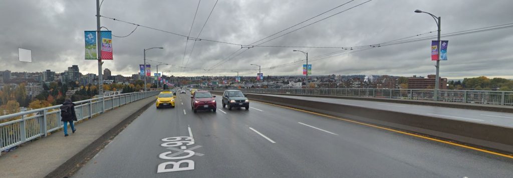
In these two current Streetviews of the Granville and Burrard Bridges, I counted the number of pedestrians, cyclists and cars – and yes, I know the weather is distinctly different in each. (Click title of post to see images.)


Roughly, about the same number of cars on both, a few less pedestrians on the Granville, but no cyclists. Notice, especially, the four south-bound lanes: empty.
That’s why the City’s proposal for a new walking, rolling, and cycling path across the Granville Bridge, without adversely affecting vehicles – cars, trucks, transit – is doable. Just as we did on Burrard.
The draft project goals are to:
– Make walking, rolling, and cycling across the bridge accessible, safe, and comfortable for people of all ages and abilities.
– Provide direct and intuitive walking, rolling, and cycling connections to key destinations and to the rest of the network
– Create a special place that provides an enjoyable experience for all.
– Accommodate motor vehicles, considering the needs of transit, emergency services, and people driving.
– Design with the future in mind, considering related projects and opportunities to coordinate work.It was identified as a priority in the early 2000s as part of a False Creek Crossing Study, and included in the City’s Transportation 2040 Plan (2012).
Your chance to participate in the design is coming up.
In this first phase of engagement, we’re looking for input on the project goals, a better understanding of how you use the bridge today, and any specific ideas or concerns you have. We also want to hear your big ideas about the bridge!
Later this year, we’ll come back with concepts for you to review and help us develop further.
There are three open houses for Phase 1 of public engagement:
Date: Friday, April 12, 2019
Time: 11:00am – 7:00pm
Location: CityLab (511 W Broadway)Date: Saturday, April 13, 2019
Time: 11:00am – 4:00pm
Location: CityLab (511 W Broadway, Vancouver)Date: Tuesday, April 16, 2019
Time: 4:00pm – 8:00pm
Location: Vancouver Public Library, Central Library, Promenade Trade Fair: North End (350 W Georgia St)
There are also several other opportunities to get involved:
• The open house materials and a corresponding survey are available online (survey closes May 10)
• Future rounds of public engagement will take place this summer and fall for updates on previous phases of engagement and to review design concepts as they develop
• Workshops will take place throughout the process to allow for more in-depth discussions and idea exploration (free, registration required – see website)To learn more about these opportunities, and to stay up to date on the project:
• Visit vancouver.ca/granvilleconnector
• Sign up for the project email list on our website
• Email us at granvilleconnector@vancouver.ca


A nice baby step approach that doesn’t offend anyone like Burrard.
The issue main is access. It’s a very high bridge – tough and inconvenient to access on either end and then onto seawall and Granville Island.
Will the elevator and bus island go ahead ?
Where is the comprehensive debate about lower bridges over False Creek friendly to motorboats, kayaks, surf boards, e-scooters, e-skateboards, wheel chair users, bicyclists and walkers, but not to the very few sail boats ?
No elevator, at least in the short term. Nobody wants to pay for it. More likely a centre-running mixed use promenade as shown in the latest renderings. I don’t think there’ll be as much moral panic over this bridge as on Burrard, as it’s an easier case to make for reducing car lanes here. Traffic on the thing is a joke, and on 8 lanes, no less. The only tricky pieces will be merging pedestrians and cyclists to and from the approaches to the centre.
If it does go ahead with the centre promenade as shown in the renderings, following months of consultation, there are unlikely to be merges/crossings for people walking and people cycling. Active transportation users would access it at Drake and at 5ths, with lights and crosswalks.
If it ends up being a promenade on one side or the other (likely west) then there are at least two crossings of ramps, which would add signal lights at those locations. People walking and people cycling would still likely use Drake and 5th for access.
The wild card is the Fir off ramp, which if utilized for the promenade offers the potential of a lesser elevation change from the bridge to the Broadway area.
Personally I prefer Fir, that gives the greatest and most direct north south route for active transport
When will offramps, for example Fir, removed completely like the Viaducts?
At some point, the whole bridge should come down, replaced with a tunnel and a series of low ped & bike friendly bridges. It’s a monstrosity from industrial False Creek with sawmills and steam ships that doesn’t exist anymore. Unlike Burrard, which has some aesthetic appeal it’s an ugly steel bridge generating lots of noise and real estate value destruction around it.
Even for driving, Fir is the best route, as its viaduct flies over several intersections that traffic on Granville proper or on Burrard need to traverse to get to Broadway.
The Fir viaduct provides a very efficient passage to Broadway for all modes.
Ending the need for bus route 50 more than pays the cost of an elevator on each side—— 3 gov t entities trying to pass the cost to each other is absurd . Translink could solve the problem by giving notice to that route 50 is ending elevator or no elevator—– It is mostly a tourist bus very few locals use
Lots of seniors housing along the False Creek stretch. Should they have to detour around the long obstacle of the FC rail ROW, cross 6th Ave., which behaves like a highway on that stretch and then walk up a very steep hill to access buses on Broadway? Not likely.
And not just seniors. False Creek South is a medium density neighbourhood – home to over 5,000 residents.
Not many of those 5000 residents ride route #50—- Ending at alder crossing would be a10 minute return trip instead of an hour ———- The$ million plus saved could be used where people have poor ( or no ) bus service..
Not sure where you’re trying to slice off the hour. #50 travels from Olympic Village Station along False Creek to Granville Island and then downtown. So it’s an important connector between GI and the Canada Line as well as providing downtown service to the areas surrounding GI. I’m pretty certain that elevators on the bridge aren’t going to provide an equivalent level of service for those residents.
One could argue for tweaking it’s downtown routing.
It’s a sad fact that “not many” residents of almost any neighbourhood use transit. But you won’t get a higher proportion by cutting service to denser areas and adding it where density is so low they currently have poor (or no) bus service.
With an elevator / bus stop G I and neighborhood would have the best bus service in metro—-Route 50 (an extension of #15) takes an hour return—ending it at Alder crossing would still provide service for the few who use it—-Translink is underfunded but wasting money on #50 to downtown speaks volumes of its priority problem——
Sorry… still don’t get it. Which end are you lopping off? Either way, Alder Crossing seems a completely illogical place to end a bus route. What possible reason would there be to not extend it to GI at least? Or if you’re suggesting cutting off the extension to the #15 why wouldn’t you keep a connection between OV Station and GI? Makes no sense.
I’m pretty sure the elevator/bus is pie-in-the-sky. But even if they found a way to make it happen it’s a pretty big inconvenience to residents, and especially seniors, living in False Creek South to have to schlep their way onto GI to get out of their neighbourhood by transit.
We hope that it won’t offend anyone but I’m sure somebody will cook up something.
I notice four lanes southbound on the Granville Bridge photo, not three. All are empty.
This bridge naturally connects more places than the Burrard Bridge does. Cycling numbers on this bridge could surpass Burrard.
I don’t think it is tough to access at all. It connects naturally to the Arbutus Greenway, and into downtown. If one just wants to go from seawall to seawall, we have lots of Aquabus and False Creek Ferries for that.
If we want to alter the Fir off ramp, users could maintain their elevation travelling south and reach the shops on Granville St, or connect to the 10th Ave bikeway.
The debate on lower bridges over False Creek is not part of a civic discussion. It is a federal discussion. Feel free to write to your federal representatives and ask for changes to the Navigation Protection Act. The one that stops people from impeding navigation. https://laws-lois.justice.gc.ca/eng/acts/N-22/FullText.html
The centre promenade is stupid. Nobody wants to walk in the middle of the bridge. Maybe cyclists don’t care but it is a shame the old project is about catering to them. So even if they leave the sidewalks for those who actually want to enjoy the view, those pedestrians will still have to dash across traffic when they reach the offramps?
The project isn’t about cycling, it is about active transportation improvements. All modes.
There would be good views in both directions from a raised centre path. Or, it could be put on one side of the bridge and there could be better views for users of one mode, specifically those at the railing, or for all active modes if the path was raised, including for those on the vehicle roadway side. And remember those views would only be in one direction. Raising the path does have the potential of blocking some views for those in cars.
To make it safer, there likely need to be new signal lights at the ramps. Dashing through traffic should not be a design objective. Combine those signals with new standard city speed limits, not highway speeds. Depending on the decisions about the Fir offramp, there likely needs to be a set of signals there in either case.
It is all a matter of tradeoffs based on what people want in terms of functionality, access points, destinations, etc. Hence the public engagement process.
Ideally, the centre path would be elevated/ tall enough to allow a LRT / streetcar RoW under it (like the Brooklyn Bridge) – but I doubt that’s in the budget (which would have to include bridge strengthening)
I’ve heard one metre, possibly up to 2 metres. The issues aren’t just cost and weight, but also the slopes of the ramps at either end of the bridge. Those bridge end ramps are already steep enough, and addition elevation gain in the centre of the bridge just makes them steeper.
CITY LABS —— WEST SIDE (active transport) option has FUTURE potential for a greenway /active transportation route from proposed subway station at fir & broadway over viaduct, bridge & pedestrian mall to waterfront—– C O V has decided not to close the viaduct to cars at this time —- But in the future ???? —— another link along 10th from fir to to the arbutus trail would link waterfont station to the fraser river
Option 2 (West Side Plus) includes a protected bike path (bidirectional) on the Fir offramp, and it could extend south to 10th. It isn’t a full closure of the Fir off ramp, (and just a sidewalk for walking, not a greenway) but considering the lower vehicle volumes there, this would make for a very useful cycling connection with limited impact on vehicle traffic. It better maintains elevation, which matters. For bike path extensions south to 10th, Fir works better than Hemlock which has limited width, higher vehicle volumes, and a steeper hill. If the Plus option doesn’t get built in the first phase, at least selecting the West side option keeps it in play for phase 2.
All options connect to the Arbutus Greenway along 5th, whether or not Fir to 10th is added as well.
Here is a suggestion to think about at the Open Houses.
There is currently a concrete centre barrier between vehicle lanes north bound and south bound. That is a freeway design feature. Why not remove that barrier?
That would free up another metre of width on the bridge, for better active transportation facilities. More placemaking. More separation between modes.
This would allow emergency vehicles responding to an incident on the bride to cross over and use oncoming lanes, exactly like they currently do on surface streets.
This would make the bridge vehicle lanes exactly like the rest of Granville St, which doesn’t have any centre divider.
With the proposed lower speed limit on the bridge, the centre divider shouldn’t be necessary.