

“The gentrification of Chelsea was under way long before the High Line, although the park certainly helped to establish as a credible residential neighbourhood an area that previously had little open space and no park.” – Sarah Williams Goldhagen, the architecture critic for The New Republic. This article ran in the September 2, 2010 issue of the magazine.
Having attended Wednesday night’s presentation on Northeast False Creek featuring James Corner, I left with mixed feelings. The draft design of the park provides a significant number of desirable public amenities, however the looming question of affordability hangs like a shadow over all new developments in Vancouver – even parks.
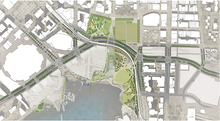
Northeast False Creek draft plan by James Corner Field Operations. Image Credit: City of Vancouver
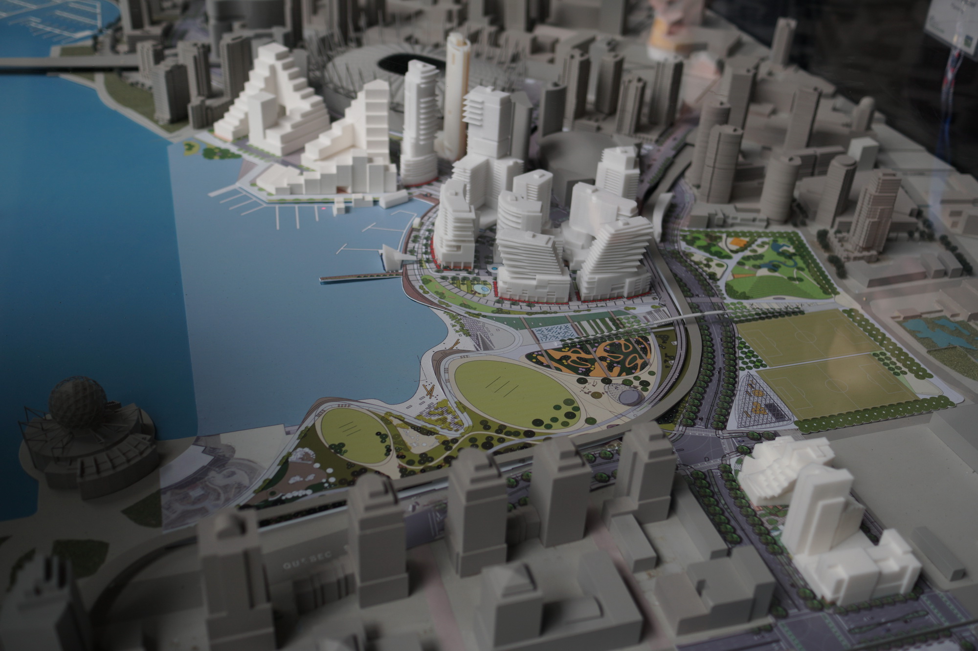
Northeast False Creek model, present at the City’s block party held Saturday June 11. Image Credit – Ken Ohrn
- The park promotes an “informality between people and places”, allowing people to clamber into and plop themselves down within “found nature”.
- There is an intent to connect people with the natural environment, which James Corner notes Vancouverites are already better at than most – due to the consistent presence of our natural landmarks (and rain). Small tactile sensations, such as the presence of moss, are being considered in the park. Tall trees may one day return to the area with the inclusion of Douglas Firs. The presence of rich, educational gardens will bring forgotten species under new scrutiny.
- Elements of the park have been informed by adjacent neighbourhoods ranging from the West End to the False Creek Flats, and from the Downtown Eastside to Southeast False Creek. The three primary contributing factors, reflective of these communities’ needs, are “destination”, “nature in the city”, and “community”.
- Tiered steps will be installed below the high tide line, allowing for each level to serve as an inter-tidal diagram, and doubling as bench seating.
- There will be a “found” beach only available at low tide.
- The park is aligned with the Ontario Greenway, so bring out your tin foil hats if you are into ley lines.
- The height of the hill in Andy Livingstone Park will be advantageously re-purposed as stadium seating to view the neighbouring sports fields.
- A sensuous, meandering boardwalk over tidal zones will challenge pedestrians to take their time enjoying and respecting the water’s edge.
- There will be places of respite, yet James Corner noted that some park management boards close their parks at night (I experienced this in Chicago’s Millenium Park, when my friends and I were hastily removed for exploring after dark). Further, some boards will design a park’s view corridors to place “eyes on the street” such that people who are homeless or whose circumstances do not fit within acceptable norms of park usage do not feel “safe” staying in the park.
- The new park attempts to include and run contiguously with a refreshed Andy Livingstone Park, but the connection is interrupted at grade by the relocated (and wide) Pacific Boulevard. A passerelle (note: not a bridge) provides a gently sloped, slender footbridge over the boulevard, while cyclists will likely cross at grade. As a person who should really exercise more often, I hope I am inclined to expend the necessary energy to walk up and over the passerelle. I wonder if the new Pacific Boulevard will one day be closed to traffic in the same fashion as the recent closure of Robson Square.
- Collaboration with First Nations stakeholders was only briefly mentioned, which I am hoping to hear about in greater detail. The draft area plan notes “The City of Reconciliation framework goals include strengthening local First Nations and Urban Aboriginal relations; promoting Aboriginal peoples arts, culture, awareness, and understanding; and incorporating First Nations and urban aboriginal perspectives for effective City services.”
- There is a raised platform for bicycles to enter the park from Dunsmuir Street, which along with the passerelle are the closest thing the scheme has to previous calls for re-purposing the existing viaducts. In the spirit of creating a place with a sense of shared memory and city history, will a fragment of the viaduct remain?
- Due to the seriousness of the housing crisis, I am curious if the ongoing exhibition at the Museum of Vancouver, titled The Vienna Model: Housing for the 21st-Century City will have an influence on the park’s neighbouring developments.
For those interested in future events involving Northeast False Creek, there is one at the Vancouver Public Library on June 13, and another at the Sun Wah Centre on June 15. For those with comments on the park, a survey is available here until June 30. For more information, the City’s Northeast False Creek website is here.


I had a look at the plans and it was overwhelming at first. It’s a huge plan with many elements and things to consider. It’s good that people have a chance to respond to it.
I mostly like it. It’s something new for the area but I’m getting quickly used to it.
The passerelle looks super-long so probably no effort walking up it.
The First Nations statement is very general. I wonder what it will end up looking like.
I highly doubt that the new Pacific Blvd will ever be closed to motor traffic. What would be the point? There will be several car-free areas in this plan so not needed.
I hope any tall Douglas firs won’t block the view of the mountains.
I think in regards to gentrification that it’s going to happen whether this plan goes ahead or not. I have no solution other than some disaster to make cities unattractive again. Other places could be made attractive and lessen the demand for nice places to live. If people in small towns could have nice places to live and amenities and employment then some will stay there and not move to a city and drive up demand.
You have to remember that at the same time that cities are becoming more attractive, smaller places are becoming less attractive. All of this means more people wanting to move to where it’s nice.
There are things to like and dislike about the whole area plan and it’s true that it is all pretty overwhelming. But there is definitely a few “what could you possibly be thinking?” elements.
There is a proposal for a major new public plaza at the former Plaza of Nations site that is defined on two sides by building frontages that are to house cafes, bars and restaurants. But it is inexplicably cut off from the seawall by a new waterfront road! This road appears to have no other purpose than to slice off the plaza from the seawall.
Because Pacific Boulevard will interrupt the plaza to the north side, before a new stadium facade creates a sense of enclosure, the plaza will span between two roads. The latter road is more difficult to remedy, but the waterfront road suggests that planners on the project (including city staff) have been reading “How NOT to Build a Great Urban Public Space”.
Then they all but repeat this travesty at the foot of Georgia a couple blocks to the east. Rather than enclose anther seawall-facing public plaza with a building, they open it fully to the steep slope of the new Georgia ramp. This can only be considered an attraction for motorists to the detriment of everyone on the plaza. Instead of a vibrant pedestrian space it will be a noisy car-focused environment, especially at night as headlights sweep constantly across the space.
There is a view corridor on Georgia to maintain, but a two or three storey building would not interrupt it because of the significant slope in that last block.
Furthermore, the eastern edge of that same plaza introduces another unnecessary waterfront road, ostensibly for restaurant access. PLEASE people! It’s a short block walk to the proposed inner circulation road of that development cluster.
While there are things to like, these three points bring the whole concept down to a failing grade.
It wouldn’t be a “short walk” for delivery trucks delivering supplies to those restaurants.
Bob, get out of town!
Literally.
Take Vienna for an example. A huge swath of car fee city centre full of establishments that need deliveries. They do it in the mornings mostly. Then from noon on the space is a wonderful pedestrian place to be.
If you have no imagination how to make this work, go and see how other cities do it.
The highline comparison is strange. This plan calls for demolition and scrapping of a functional elevated roadway not the reuse of what is there. An elevated pathway with the potential for emergency use. The viaducts end near the proposed new hospital. Also the skytrain and a highway will be running at ground level through the middle of the proposed design.
A funny thing happened at the open house. While standing in front of the model which features the six lane road that will connect to the four lane road of Georgia, a woman said “So the idea then is that you want nobody to ever drive downtown again?”.
You call it funny. I call it absurd. It is the comment of someone who has no credentials telling traffic engineers they have no clue.
Every proposed reconfiguration of roadways has come with a guarantee of traffic chaos. None have ever materialized.