
Two items in one place — a questionnaire on the proposed new St. Paul’s; and a good backgrounder on the thinking that led to the concept designs.
Click photo to get full backgrounder
Two items in one place — a questionnaire on the proposed new St. Paul’s; and a good backgrounder on the thinking that led to the concept designs.
Click photo to get full backgrounder


And so the Titanic sailed on confident in the design standards established by a motley crew driven by optimism. It is slightly insane to build a hospital at sea level. It is called the Titanic Syndrome.
If you check the City of Vancouver’s VanMap contours you’ll see that the current site level is not at sea level – it’s at least four metres above sea level. The new buildings may well be a bit higher (in the same way that the new Concert residential buildings at the end of the creek are being built at a greater elevation to respond to possible higher water levels).
The new hospital will be behind the row of Citygate towers. If and when water level issues become an urgent item you can safely assume their residents will be demanding an appropriate engineering response – which shouldn’t be too difficult as Creekside Park is in front of them.
High-high tide is around 3 metres. The site is basically at sea level.
That depends on what datum you’re using.
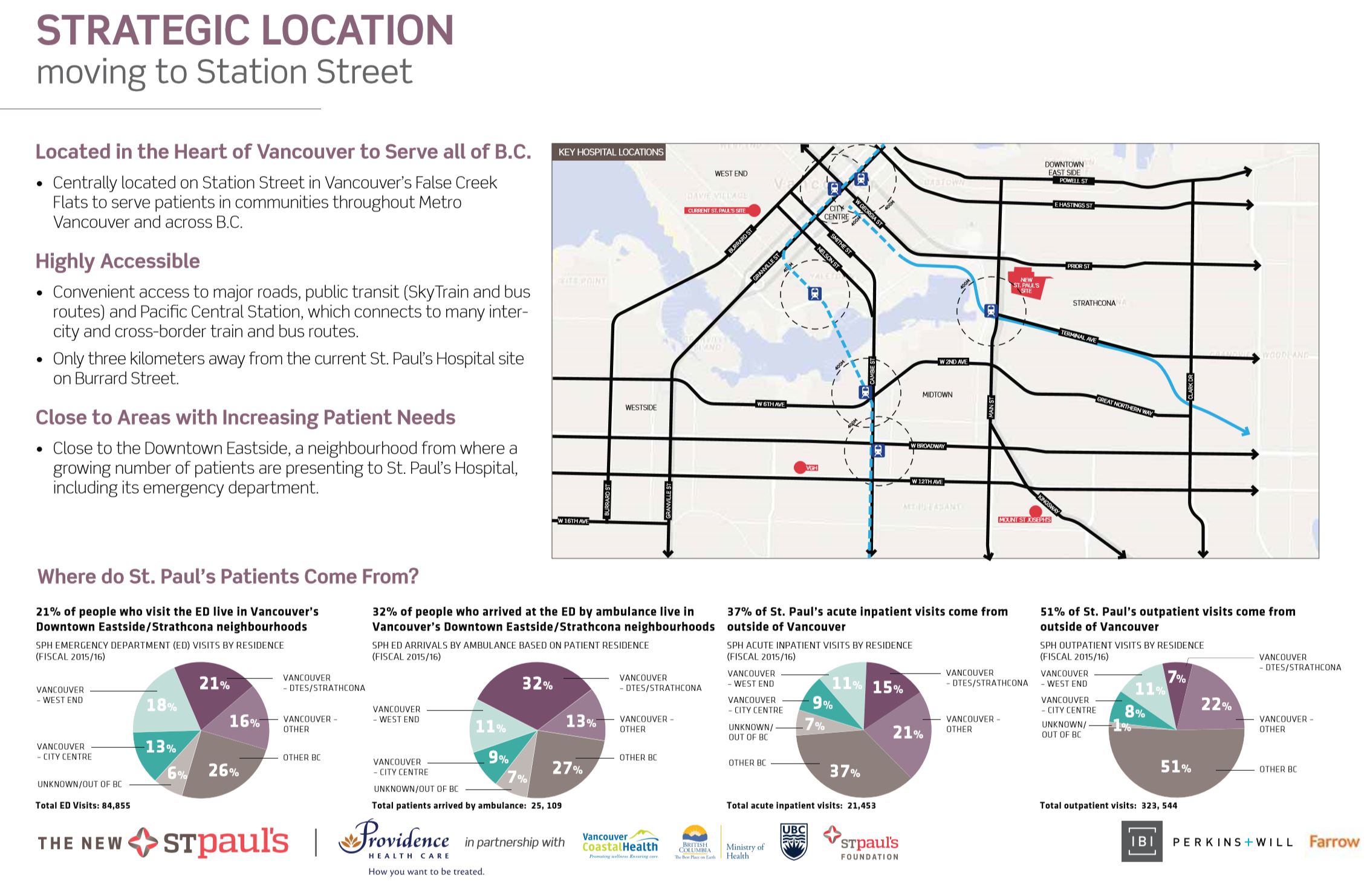
The hospital campus layout conceptualization is excellent. Close proximity to transit, mixed use (including retail at the ground level), street-oriented storefront treatments, a conveniently located hotel for out-of-town family members (hundreds a year), loads of space for associated mid-rise research and medical offices, provision to virtually double the size of the facility in future, a conscious effort to provide a sense of entry and linkage to the parks system and enhance the pedestrian realm, intricate open space treatments ….. it’s all there.
Medical facilities by necessity must be well thought out with many layers of professional and practical review. Hopefully their “design for healing” efforts will include banning the 4-patient ward altogether for at minimum 2-patient wards and private rooms, wider halls, a good distribution of nursing substations, and such. The latest healthcare design precepts out there are quite progressive and promote dimmer lighting and lower noise levels and other protocols on wards, the use of atria and solariums in common areas, and family / ward lounges that admit natural light and are ideally placed for views. These are some of the elements that should become part of standard 21st Century best practices programming. To their credit, they are making provision for significant separate mental health and addictions treatment facilities, which as everyone knows is a highly visible issue on the streets of Vancouver and in the nearby DTES. The existing St Paul’s E department often gets overwhelmed with people suffering from these maladies.
One quibble. On the technical side they seem to address seismicity only from the standpoint of meeting the code, including geotechnical remediation. In fact, with any long-term aspect regarding facilities as important as new hospitals, they should be exceeding the code by a wide margin. The planners and architects of new hospitals, city halls, prime emergency facilities and so forth on the Coast should take a look at Christchurch NZ or Kobe Japan, both of which suffered from shallow earthquakes that did a lot of damage because the epicentres were directly below the cities. I suggest top-rated buildings like this should incorporate shock-absorbing dampers under and within the building. This will minimize the damage and injuries from severe lateral motion in addition to keeping the building standing. All service connections should be flexible to stay unbroken during quakes, and the use of natural gas for heating should be avoided for safety during earthquakes and to minimize emissions and operating costs over the lifetime of the building.
Perkins Will has a lot of experience with geothermal and LEEDs, but this one should go a lot farther. The latest additions to Rockyview hospital in Calgary have triple glazing and no doubt some pretty stout heat recovery capability in their air exchange units. There is obviously a lot of investment in energy efficiency and it stands to reason this should be given more serious attention considering the longevity of such facilities and the unpredictability of fossil fuel prices over time (quite literally a roller coaster).
Regarding sea level rise and storm surges, if I interpreted the panels correctly, the elevation will be raised by about 4.6 metres presumably on structural fill above the 5m of the site, so there is a built-in buffer of a century. However, though the rise is almost imperceptible today, it is anticipated to blow through the original 0.55m rise by the end of the century predicted by the IPCC, perhaps ending up at 1.5 – 2.0m the way things are going. The city around the hospital will be in greater trouble, and this begs the question of planners at all levels to project ahead to raising the seawall within 80 years. Even that’s not a long-term solution, so perhaps the hospital planners should stick to at most a 100-year design, and leave redesigning the city below 20m elevation to another generation. But they better start saving up now.
City Engineering measures land and sea elevations in the Geodetic Datum System.
2.84 GD seaside walkway I am guessing
3.04 GD is the False Creek shoreline water level upper estimate for 1:500 year event according to the City of Vancouver Coastal Flood Risk Assessment report (VCFPA).
4.04 GD add 1metre of sea level rise in next 100 years (VCFPA).
5.04 GD add 2 metre of sea level rise in next 100 years (MB speculates).
5.04 GD plus add extreme weather events, storm surges, high winds, and then guess how high the water.
4.42 GD the existing level of the hospital site according to the project backgrounder
4.60 GD Flood Construction Level established by the City. Incidentally this number will be revised if necessary, and just in case things don’t work out the project owners will be asked to sign a floodplain covenant which will likely require the project owners to indemnify and save harmless the City of Vancouver. Translation; It doesn’t really matter what the Planners say.
5.00 GD the proposed first floor level of the hospital
I think it is fair to say that in this sea of estimates, guesstimates and averages this project is proposed to be built very near sea level! There are only a few places in the world where hospitals have been built near sea level; the Netherlands where there is no high ground, and Venice which is inundated by the sea.
The planning for this project began before there was an awareness of sea level rise. Now there is an understanding of this issue. But even without this issue we are pretty much at sea level when we could be on high ground.
MB. You have a good sense of the program requirements of this project. So a question to you; How many stories would we need if this project (the hospital component) were built on the Larwill Park site?
Jolson, I’m not an expert, just an interested designer who had his eyes open as a participant in family elder care over the years.
I don’t believe Larwill is an appropriate site for a hospital. First off, the block has only ~10,700 m2 of developable land, about 1/3rd of which became encumbered when the city set it aside for private development to offset, I believe, the cost of a potential new VAG. That leaves only ~7,000 m2.
By comparison, the existing St Paul’s block is ~26,700 m2, but is also encumbered by the Heritage A-rated original hospital building which will largely be protected and seismically upgraded as part of a future development plan. Façade retention will likely be the minimum requirement. Moreover, the newer buildings are still viable and will probably be promoted as adaptive re-use condos or offices.
The Station Street site is also encumbered by potential road easements. However, the developable still area rings in at ~52,600 m2, enough to build a campus with deeply inter-related functional relationships and room for future expansion.
Hospitals require large floor plates, so the point tower form would be inappropriate. Elevator shafts bisecting wards just doesn’t work well programmatically. The Pattison Pavilion at VGH is a broad tower form with large floorplates that accommodate circulation and ward functions quite well. The proposed new St Paul’s as illustrated is obviously long with large floorplates in a mid-rise form.
If you are right with your GD stats, then the main floor elevation (not to mention the entire Flats area) will be subject to flooding during storm surges perhaps by mid-century if they occur at high tide. In my view they need to be planning for 100 years when it comes to vital infrastructure like hospitals. So that again begs the question, how is the city planning to mitigate the 1+ metre in sea level rise by the end of the century? The province is already quietly planning to raise the dikes on the Fraser, some of which were just completed a few years back.
OK but, let’s say that the VAG proposal fails. That the entire Larwill block is available. That the QE can move elsewhere, and that Cambie Street can be closed as city planners previously suggested, then we have consolidated a suitable site next to the old post office block. How about that?
MB: not to get sidetracked but in regards to your question; how is the city planning to mitigate the 1+ metre in sea level rise by the end of the century?
I suspect that the answer is not by raising the seaside walkway.
Water does not run up hill. Raising the seaside walkway and therefore the level of False Creek means that the False Creek drainage basin is below sea level and will require pumping forever.
A better strategy might be a sea barrier across English Bay to Spanish Banks, a set of locks for boats and for discharge of storm water from the creek to the ocean at low tide (the Venetian strategy). Add a pedestrian-bike route along the top of the barrier. The First Avenue Street car alignment will be handy and should be retained for moving the enormous amount of fill material by train that will be required for this effort. This will be a big project. This will be the most important urbanist project the City will ever undertake.
Also add a sea wall along Burrard Inlet where needed.
All of this means that at some point parts of the City will be permanently lower than the ocean that surrounds us. This is true for the proposed hospital site and its environs, all of which will be at constant risk of a breech much like New Orleans is today. Yes you can flood proof a single building like a hospital, but to what point when the neighbourhood is under water? This is why I maintain that the hospital should be built once only and on high ground. I am arguing for a sustainable future. We should not be impacting the environment over and over because we refuse to do it right the first time. (The Titanic Syndrome)
You can accomplish a lot with small increments over a long time, which implies we shouldn’t let it get to the point where we rely exclusively on humongous geoengineering projects. In the end the Metro may discover its most affordable solution will be to slowly devote its lowest lying land parcel by parcel to estuaries and marine ecosystems. This also implies we need to learn to build at higher densities on slopes and higher elevations, of which there are plenty.
Holland is allowing controlled flooding to take the pressure off the barriers. Most of their nation is at very low elevations, like the Fraser Valley, and therefore they find geoengineering more important. But eventually they may have to start emigrating. Our geography permits future climate refugees from Richmond and other sea-level communities to emigrate to the Burrard peninsula and the North Shore.
The fate of low lying lands such as False Creek with its very high shoreline densities will not mean the wholesale abandonment of its neighbourhoods to the ocean environment. You should expect a sea wall across English Bay within the next 85 years. Long range planning on this time scale is not something humans are good at doing, we are more tuned into four year election cycles, land use and transportation plans that evolve incrementally, and momentary self-interest that is best served by silence and denial of events inevitable.
In regards to building a hospital on the Flats there is also the flip side; we might look back one day and say that it was a decision that led to the building of a sea wall.
“Pumping forever” would mostly imply that you wouldn’t store storm water for low tide.
Maybe we should be talking to naval architects about designs for hospital ships!