
The Vancouver Sun has written an article on the future of flooding in Metro Vancouver, and it is not a pretty picture.
The Fraser Basin Council has done some research and is suggesting that close to 71 per cent of the dikes in the area will fail with a major flood or climatic event from the Fraser River or from the ocean.
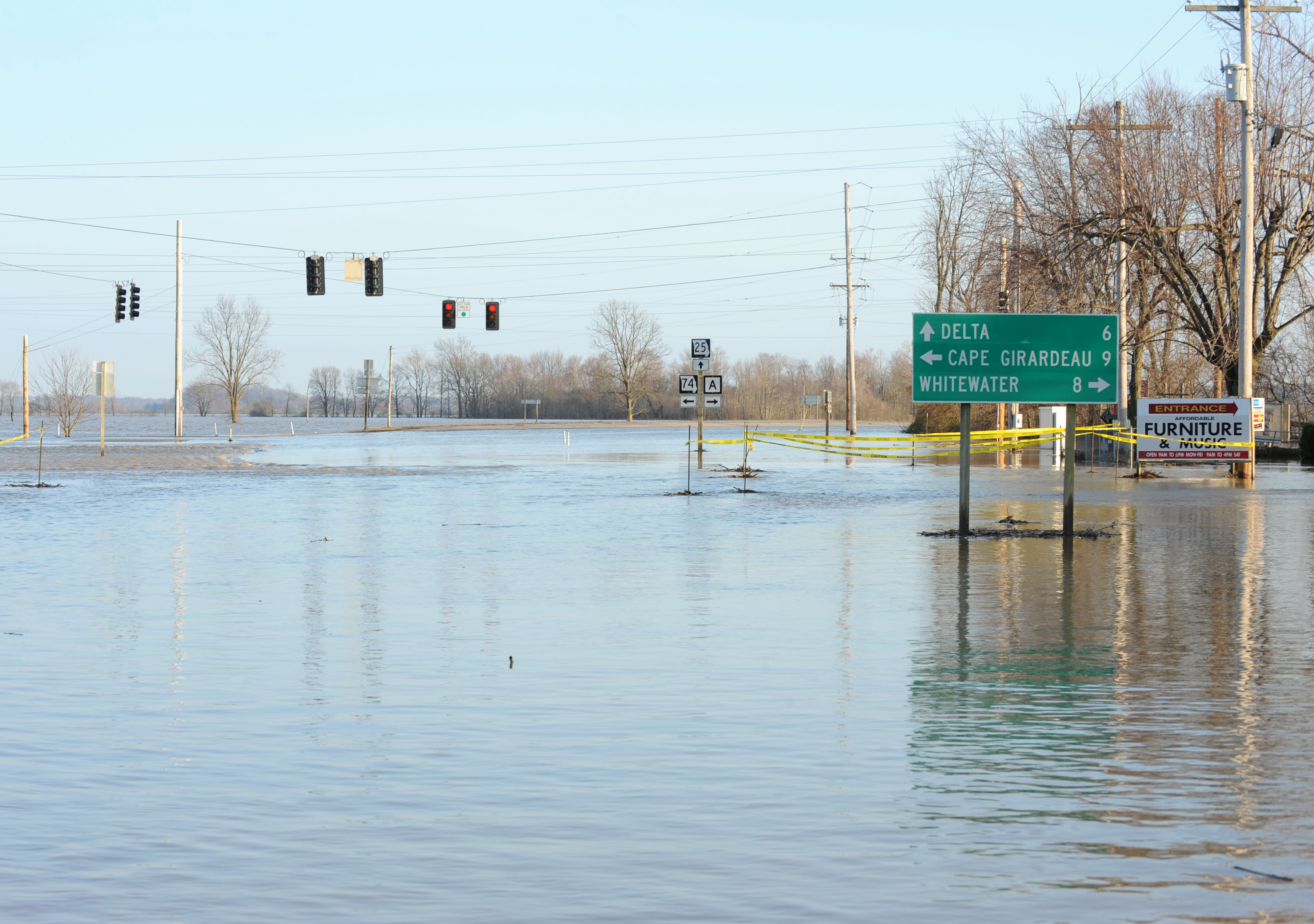
The study newly released last week suggests that nearly 110,000 hectares could be underwater, with transportation and food routes cut off. Lower Mainland floods are projected to worsen over the next 85 years. These impacts can be mitigated with proactive planning and comprehensive management of dike building and restoring. The study also showed that many of the First Nations settlements in the area will be severely impacted by storm surges and/or flooding.
An earlier study had suggested that the costs of dike upgrades would be in the $9 billion dollar range. This compares to the potential flood damage being $22.9 billion dollars today, to an estimated $24.7 billion dollars in the year 2100.
The cost of increasing flood protection will be determined in the next phase, but Fraser Basin officials noted that an earlier study had pegged the cost of dike upgrades at $9 billion.
The City of Vancouver has identified 11 areas in need of flood mitigation and has been working on a flood plan for the past five years as part of its climate adaptation strategy. Those impacted lands include False Creek, Coal Harbour, Stanley Park and the Fraser River lands. It is unfortunate that several of these areas also contain a lot of housing.
New houses in the city must also be 4.6 meters above the main tide levels. I have been specifically watching the prices of houses north and south of the 3500 block of West 48th Avenue-the north side of the street and the streets to the north are above the flood plain, the south side of the street and the streets to the south would be underwater if subject to a flood. So far realized sale prices on both sides of the flood line are consistent, and not reflective of the potential flooding problems.
Is it enough? Should the city be warning potential purchasers in impacted lands of flood concerns in these areas? What about housing located near the Fraser River in the rest of the region?


Author
Reblogged this on Sandy James Planner.
A real environmental threat Sandy.
This from 1948
http://searcharchives.vancouver.ca/aerial-view-of-fraser-river-flood-and-surrounding-areas
Here’s an interactive sea level rise map that may be helpful to see the flood risk in various locations, based on elevation:
http://ss2.climatecentral.org/#12/49.2373/-123.0507?show=satellite&projections=0-RCP85-SLR&level=0.5&unit=meters&pois=hide
Note that even at a 1/2 metre rise many areas south of the Fraser are inundated. I would think that anything up to 2 m would also be indicative of the possible flooding where dikes are breeched along the Fraser during a flood from high snowmelt from its 90,000 km2 watershed.
There are a few issues that should be addressed in these reports. One is the ability of soft alluvial soils to support the weight of additional material added to the dikes. If the dikes start to sink from their own weight then that kinda defeats the purpose, doesn’t it?
Another is the infiltration of water from below. This is already happening in Richmond where salt water is seeping into the drainage ditches near farms. If the Fraser rises a couple of metres above average, that pressurizes the ground water.
Another is the seismic stability of raised dikes. I wonder if they need to be layered with neoprene fabric or something to hold them together, which is a common practice for stabilizing the earth behind some kinds of retaining walls.
All it will take is one big flood and one Richmond dike to breech to make it plain as day that building a city in a floodplain, let alone on low lying land next to the sea, is not a good idea. Will floating cities be common on the South Coast in the 22nd Century?
Floating neighbourhoods … it’s already started:
https://i.ytimg.com/vi/0IFkcPml_tw/maxresdefault.jpg
Floating cities … some crazy ideas are already out there:
https://www.google.ca/search?q=floating+cities&safe=off&biw=1519&bih=706&tbm=isch&imgil=dLtqKmUJv7DFKM%253A%253BuDt-DlzYARea-M%253Bhttp%25253A%25252F%25252Fwww.seasteading.org%25252F&source=iu&pf=m&fir=dLtqKmUJv7DFKM%253A%252CuDt-DlzYARea-M%252C_&usg=__O0WTbnkg8eZLvgdkWMBsUnD5mDA%3D&ved=0ahUKEwjhnt_0lorNAhWDxRQKHepoDF8QyjcIJg&ei=o5ZQV6HBPIOLU-rRsfgF#safe=off&tbm=isch&q=floating+cities
” building a city in a floodplain, let alone on low lying land next to the sea, is not a good idea. ”
Seriously, Sandy ?
You like to insult the Dutch that badly ? 2/3 of Netherlands is below sealevel. All well managed.
Are these predictions reliable ? How much will it really rise ? 2cm ? 2 meters ? 20 meters ? 2 mm ?
Or we in the age of disinformation ?
https://medium.com/@spann/the-age-of-disinformation-98d55837d7d9#.28yafgvil
http://ecowatch.com/2016/04/06/climate-change-flooding/
https://science.house.gov/news/in-the-news/climate-exaggeration
Politicians LOVE dire predictions. “I am here to serve my constituents” they say. Just give me more power, more tools and of course, MORE MONEY and we’ll fix it. Just vote for me.
Like many, I am always extremely suspicious of these dire predictions. Yes, we may have to shore up the dykes a meters or two. Woopee doo. in 86 years. I think we can manage that.
Sorry Sandy. MB said that. Not you.
The main point about the Dutch is that they get climate change and are preparing for it, not just with floating communities but by designing new floodways that act like a relieve valve, elevating towns and farm buildings, and building massive mechanical barriers.
As for “shoring up the dykes a metre or two … Whoopee doo…”, the highest point in Richmond is already ~1m below mean high tide, more during storm surges and the king tides. The soils are soft and won’t support a lot of additional weight (e.g. higher dikes without spread footings — buildings have massive floating concrete footings) and as mentioned (but ignored by you), the ocean is already seeping in from below.
Long range planners and decision makers have some very challenging work and tough decisions ahead.
And thanks for the links to disinformation. It only confirms you won’t find it in the peer reviewed research, but in the vested interest-funded sites and blogs of those who will say anything to reinforce their iconoclastic, libertarian self-image.
Disinformation is everywhere, kinda like quoting the weather guy from Alabama as an expert on climate change.
Denial is not just a river in Africa.
There is enough public govn’t information that I do indeed live in a condo in a flood plain in Calgary by the Bow /Elbow River which flooded the Calgary region (High River and Canmore also) in June 2013. I was 1 of 100,000 residents evacuated for 5 days. (By coincidence I returned to Vancouver to chill…in time for a water celebration….the annual Alcan Dragon Boat race. It was very surreal while I was monitoring the flood disaster on Calgary tv news at least twice each day while in Vancouver.)
A few years later, are prices reflective of homes located in that area? I don’t think so. I haven’t done a scientific analysis but I have seen home sale prices in my neighbourhood for past 2 yrs., that aren’t noticeably “discounted” because it’s in the flood plain.
Note that a huge chunk of Calgary was not affected by the floods at all. Many locals don’t have metre by metre knowledge of exactly which corners along the riverbanks overflowed and depth of flood water.
The newly built urban enclave of vibrancy East Village was under several ft. of floodwater. http://www.evexperience.com/condos
Photo of East Village under flood waters, https://en.wikipedia.org/wiki/2013_Alberta_floods#/media/File:East_Village_Calgary_Flood_2013.jpg of which many shiny new high rise buildings featured in the recent photos provided by the developer did not exist. See previous comment link.
Thanks Jean. I know Calgary well. I love the Mission neighbourhood, and walked through the beautiful post-flood Roxboro and Rideau Park neighbourhoods last summer. About every fifth house along the Elbow River was demolished and the city was converting many of the empty lots to park space. Most everyone living there are wealthy enough to be able to afford take the risk of living without flood insurance coverage. Those who rebuilt (or heavily renovated) after the flood now have elevated houses with living space and mechanical / electrical systems at the second floor level, which leaves open breezeways and garages with blow-out walls to accommodate flood currents. Call it the New Calgary Architecture. The Mission B&B where I frequently stayed is in a heritage house only one block from the river and had good insurance but it was still only partial coverage that traditionally excludes floods in a flood plain. They are still waiting for their $100K claim to be paid out by the province, which is still processing in excess of $5 billion in claims for damage not covered by private insurers.
This begs the question of just where the limits to taxpayer bailouts are supposed to be set in a world of increasing climate risk to those living in flood plains and so forth. And the mitigation strategies are also horrendously expensive. In Calgary engineers are proposing spending more billions on diversion channels and large-diameter tunnels to take flood waters around neighbourhoods in the valley. The flood occurred three years ago, but they are still flushing and reaming out the hardened sewage-contaminated sediments that clogged the downtown sewers.
That particular flood was linked by some scientists to the distortion in the jet stream patterns, in turn caused by a warming Arctic Ocean, which caused them to slow and lock-in successive waves of storm systems over one location. Remember, this is not the only major flood Calgary had in the last decade, and they are now punctuated by drought and a looming major mid-century water crisis due to the much diminished glaciers feeding Prairie rivers.
So, what is the long term plan? Oh yeah, to extract and export more tar sands products with very few value-added benefits and without regard to the regional and downstream emissions that contribute to this mess.
Indeed we need to link locations with higher flood risk to payments for such risk, say through far higher property taxes. We cannot expect highlanders to bailout lowlanders that get the river or ocean front view but then ask society to pay for their flooded basement or swept away house.
I know nothing about the Alberta govn’t program for payouts to home owners for their flood damaged homes. It would be surprising the govn’t would pay a homeowner high amount of $100,000 for amounts not covered by private insurance. Expropriation/demolition of homes (there were a handful) for homes clearly uninhabitable, severely damaged and never to be rebuilt on same lot because too close to river, is a different scenario.