

Shared space is “a design feature that aims to encourage pedestrians, cyclists and drivers to share the same deregulated space.” The concept can be traced back to the work of Dutch traffic engineer Hans Monderman, who in 1982:
… hit on the idea of removing signs and street furniture to create a flat even surface where travelers of all modes had to negotiate rights-of-way among themselves. Exceeding even his own expectations, Monderman found that the plan cut vehicle speeds by forty percent. The absence of all traffic controls increased drivers’ awareness and thus forced them to slow down.
Given the issues related to the 800-block Robson, it’s a a highly relevant idea for Vancouver. (Though one can make the case that Granville Island, opening in 1979, was a pioneer in shared spaces.)
When I was in New Zealand last October, I got a chance to check out experiments by our Commonwealth cousins in Auckland – notably a block of Elliott Street, one of their first tries, in the downtown core.
You can see an earlier version of the street here before its transformation to this:


.
Merchants, once hostile to the idea, are now clamouring for their own shared-space streets as they see the commercial success of more recent projects like Jean Batten Place and Fort Lane.

.
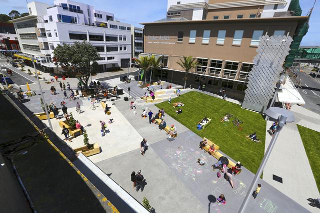
My host, Isthmus, an Auckland-based international urban design practice, is doing similar work elsewhere in the country – most notably, the lower Brougham project as described on their blog:
In June 2010 New Plymouth District Council was one of two councils awarded funding from the NZ Transport Agency (over two years) to develop walking and cycling initiatives within the district. After carefully surveying the district for suitable sites, council selected the portion of Brougham St between Devon and Ariki Streets (map here) …
The task: “create a ‘flexible’ space in front of the library that could accommodate a range of activities and could be programmed spatially for a variety of events while reducing the prominence of the automobile.”
Before:

.
After:
.
… departure from the typical streetscape upgrade came by way of the team custom designing a series of movable benches and planters that allows council to configure the street furniture to shape the space for the desired activities. This is ‘flexible’ space in an urban context in its purest form.


.
Some cautionary notes from the Journal of Urban Design:
The Attitudes, Perceptions and Concerns of Pedestrians and Vulnerable Road Users to Shared Space: A Case Study from the UK
The concept of shared space is increasingly being incorporated into urban areas in the UK, promoting a major change in the way streets are designed.
However, there is a lack of evidence underpinning shared space, in terms of attitudes and usability, particularly for vulnerable road users including blind and partially sighted, elderly and wheelchair users.
This research used street accessibility audits and focus groups with vulnerable pedestrians and 100 completed on-street questionnaires to investigate attitudes and behaviour towards a shared space scheme in Hereford, UK. The findings have shown that despite being very positive towards the scheme, particularly in terms of aesthetics, pedestrians and vulnerable road users had a number of issues and concerns with the design and usability of Widemarsh Street, in particular with nuances of design including the kerbs and vehicular access to the street.


Daniella has called Granville Island’s shared space ‘a giant parking lot’ and I’m inclined to agree. The details that contribute to this (perhaps most obviously, the ability to park, which isn’t present in your photos above) would make for interesting analysis: http://stroadtoboulevard.tumblr.com/post/30271964009/granville-island-woonerf
Walter Hardwick Avenue in The Village works better, so I highlighted here:
http://stroadtoboulevard.tumblr.com/post/29080365743/converting-a-stroad-into-a-modern-arterial-multiway
I stayed in a house in the medieval core of Middelburg NL for a while and came to love the shared streets that had paving that went building to building in an undifferentiated single plane. (The street I stayed on, Spanjaardstraat, is so narrow that it is actually pedestrian only for a portion, and it does have small curbs but mostly to control rainwater.) I hope that some of the Flats redevelopment could be done on this style so that a true pedestrian square – with building to building undifferentiated paving – could be created.
A puzzle in Vancouver is why Granville Island works and Gastown does not. Gastown is not really shared space, but it is in parts, yet it really does not work. People drive too fast all the time, so much so that it can be an unpleasant pedestrian space at times. The one-way street for cars is certainly a contributor to this, but Granville Island is one-way too. This might be a suitable area for an experiment in fully undifferentiated space to see how much of a difference shared space would make.
I have also wondered whether Denman might benefit from not so much shared space but paving that went building to building in a single plane. During the summer the sidewalks are packed and should be expanded. If the street were paved in a single plane, the pedestrian area could be expanded to include the parking lanes. In winter it would shrink to the current sidewalks. Because the areas would be changing, I think that moveable bollards would have to be installed so that people got the picture come May 1st.
Calling Granville Island shared space is like calling any large mall or big box store parking lot shared space. It is not really shared anyway. There is far too much traffic for pedestrians to walk down the middle of the street. There would be no point as often the traffic is moving slower than walking speed. When it is moving faster, I expect honking would quickly force pedestrians to the side.
It is time a good portion of Granville Island is made carfree. There has to be better uses for all those funky old industrial buildings than just covered parking lots.
Water St. in Gastown is the westbound half of a two one-way couplet system (Cordova Street being the eastbound half) for commuters entering downtown from the Second Narrows Bridge (via McGill St. and Commissioner Street). Expect it to get busier if the viaducts are demolished.
I doubt that parking on Granville Island will disappear until the streetcar (or LRT) is built on the 6th Ave. RoW. There needs to be a viable transportation alternative, since the local (walking) community wouldn’t be big enough to support the variety of uses on the Island. Remember around the Winter Olympics when all parking on Granville Island was pay parking? They reverted back to free 3 hour parking pretty quickly afterwards.
Regarding Walter Hardwick Ave in the Olympic Village, does anyone think that the heavy bollards create more visual separation between the pedestrian realm (sidewalk) and roadway than a conventional raised sidewalk would create? With a conventional sidewalk, you wouldn’t have the chunky sentinels every few feet (and a long plain curb may highlight the absence of continuous street trees).
Granville Island
As mentioned in the post, the Granville island design is a pioneering 25 years old, and people have to keep that in mind:
In despite of some weakness, It is the best (“only?”) shared space you can enjoy here and is so far an unmatched success. So what is the need to change that when so much need to be done elsewhere?
Widemarsh Street (Hereford UK) (“Cautionary article”)
Notice that the design include a low level kerb- to ostensibly make blind people aware of the road partition: the result is that you have an obvious road partition!… with a kerb, unfriendly to wheelchair, and keeping pedestrian on the “sidewalk”,… and eventually the kerb not visible enough, is involving ankle pain once in a while…
As the article recognizes: a case per case approach is necessary, and the Auckland’s Elliott street seems way much better designed that Hereford’s Widemarsh Street.
I can’t imagine that the Aukland design is hostile to blind people, and guess blind people orientation/safety needs is addressed by careful texture change/ gentle bump in the pavement like now usually done (the tram example and Exhibition road presented here, have it )
Denman Street
I also agree, that the treatment of this street is certainly the most pressing need. A full Shared space is an option worth to consider, thought some other could be eventually more appropriate :
http://voony.wordpress.com/2011/04/25/denman-street/
800 Robson
Shared space concept is the obviously way to go (nevertheless, could be limited to bus/bike). Hopefully the city will give a serious look at it.