
Thanks to Beyond Robson for picking up on the City staff report going to Council on Thursday, recommending the study of a new site for the proposed Whitecaps Stadium – now behind the Waterfront Station and over the Seabus terminal. Much better.

And while Council is at it, maybe it’s time to be more creative about the Burrard Bridge bike lanes. Last estimate: $20 million to widen the deck to create safe space for bikes and peds, and that’s probably low-balling it.

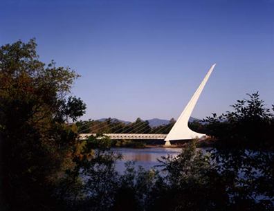
Seriously, how about a separate bridge – one that would connect the seawalls and allow for something truly iconic to frame the entrance to False Creek. There’s got to be some wanna-be Calatravas who could do for Vancouver what he did for Redding, California.

The Sundial Bridge cost $24 million at the time.


Ummm, what do you mean much better? It’s located ON TOP of the SeaBus terminal.
The City Staff report says very little about how/if that critical piece of the regional transit network will be safeguarded. Makes me very very nervous.
The Portside proposal had proposed to push the seabus terminal further out into Burrrad Inlet. Other studies on development on the Port lands have pushed it to the east along the shoreline.
Location probably will depend on the elevation of the stadium, its surrounding streets, boardwalk and its stands. If Canada Place Way is extended to the east at a high elevation as was proposed for the Portside project, there could be space underneath the stadium. If the stadium is to be built at a lower elevation – stepping down to the park and Gastown, they’d probably have to get more creative.
The worst thing about the separate bike path for the Burrard Bridge proposed by the City was its connection to the street. At the open houses, the displays showed the separate underslung bike path criss-crossing with pedestrian path at each end of the bridge to get back to the roadway. The placement of the separate bike path on the underside of the bridge is a significant flaw. The underslung path is allocated to bikes because it is too secluded and dangerous for pedestrian traffic.
As it is now, pedestrian and bikes may “sideswipe” each other if they aren’t paying attention. With the underslung proposal, you may b=have full blown “t-bone” crashes.
Further into Burrard inlet? It’s already an unfortunately long walk.
If the so-called hub is to be a successful intermodal terminal it has to seriously consider the transit interchange function. Remember that people will be transferring not only from SkyTrain, West Coast Express & SeaBus, but also the Canada Line (aka RAV) and local buses, not to mention a potential future streetcar.
The distance between these modes must be minimized, which is why I am very worried about any move that would force transit users to walk even further. Equally, if not more important, is the question of how many grade changes would need to be made. Remember, people need to get from the water, up over the rail tracks, and back down to the ‘below grade’ platforms for RAV, SkyTrain & WCE – which are not incidentally as close together as one might hope…
Since we’re (apparently) trying to promote transit, you’d think these critical questions would be getting a bit more attention.
There are some new diagrams on the Whitecaps site:
http://www.whitecapsnewstadium.com/renderings.cfm#rendering6
http://i79.photobucket.com/albums/j155/starfcuk/renderings_vanmap.jpg
They show this for transit links – note the Seabus route. Not sure if you can extrapolate that the stadium would be above the terminal, however.
http://www.whitecapsnewstadium.com/data/upload/renderings_transit.JPG