
PART 2 of the extended essay by a guest writer, Peter Marriott, on the question of transit on Robson Street. Part 1 is here.
.
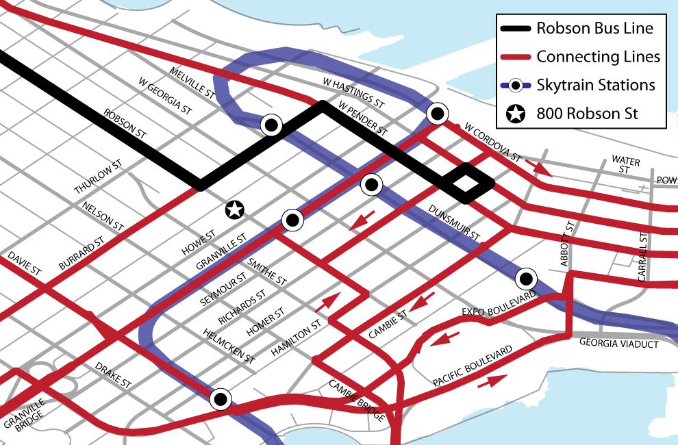
Beyond Robson: Connections and Alternatives
The problem is summed up with a simple observation: the Robson line doesn’t just serve Robson! A transit line in a connective transit network serves a market far beyond just the areas that individual line travels through. The #5 isn’t just taking people from the West End to Downtown; through connections, it’s taking them all over the city, to major destinations like Central Broadway and beyond to the region.

The map above is a (simplified) schematic of the key parts of the transit network that the Robson line interacts with. The question is how to make this interaction as seamless as possible.
It’s impossible for a single transit line to efficiently serve every destination that its passengers might be travelling toward. This is why, if we want transit that effectively and efficiently attracts riders, connections are essential, and the optimum network structure is a grid. The most significant impact of closing Robson Square is that the Robson Line no longer connects with the Canada Line nor with the abundance of frequent surface transit lines that run on Granville. Connections with these services, which serve trips to South Granville, Central Broadway, the Cambie Corridor, the Airport, Richmond and beyond, will now have a 300‑metre gap, or 10 minutes of out‑of‑direction travel for every trip:

.
Can this problem be solved? The City’s survey about closing Robson Street, unfortunately, offers only this rather disingenuous message about transit (click to enlarge):

The message from the City, just like the VPSN and other groups, is: “don’t worry about transit, because the route will be changed.” Again, “thoughtful planning” will resolve everything. But, of course, no routing options are actually shown in the City’s survey.
In fact, the only realistic “short‑term re‑rerouting improvement” that’s possible with Robson Square closed to transit is a minor modification to the trolley wire to replace the loop around Thurlow, Haro and Smithe with a left turn directly onto Burrard from Robson:

The astute observer will note that, despite the City’s text, this route does not serve the library, nor shopping on Granville Street, nor theatres. And the gap remains, with poor connections between Robson and Granville.
In the longer term, there isn’t a feasible better alternative. Georgia Street is so congested that the suburban buses that operate on it are slow, unreliable and routinely detoured onto Pender, and there would be safety and operational concerns with frequent turning movements at Burrard and Georgia.
The only other options are one‑way streets that would be no improvement over the current Pender detour. Moreover, any of these new routes would require a significant expenditure on new trolley wires—not to mention time for planning and engineering the route change.
.
Closing a street to private vehicles is a fundamentally different question from closing a street to transit, and it’s unfortunate that the two questions are being conflated here. Buses, especially trolley buses, can’t just go onto “some other street” at a whim. Transit, uniquely among transportation modes, requires efficient, legible and direct connections, because many trips aren’t made on a single vehicle. Again, this is a geometrical problem.
Here’s the bottom line: closing Robson Square to transit means perpetuating the current route, with only a minor improvement, and it means perpetuating poor transit connections between Robson Street and the rest of the transit network. That is the fundamental tradeoff here and, even if the street ends up being closed to transit, that tradeoff needs to be acknowledged and reckoned with.
.
TOMORROW: Connections and Ridership Goals
* Bold emphases mine.


If the 800-block Robson St is to be closed to all vehicles, including transit, the only reasonable route option, to my mind, is to turn south on Thurlow, then to Nelson, and then turn onto Granville northbound. This would require new trolley wires, however (if I’m not mistaken).
Seriously? The author should look at his own map. The 6 routing connects with the Granville Buses and the Canada Line at Pender. The south Waterfront entrance is between Pender and Hastings. The walking distance is likely only a few metres difference compared to accessing the 6 on Granville and Georgia. There are also no theaters left on Granville Street.
This all reminds me of the reaction to other changes like Burrard Bridge and Hornby. Yes, changes are required. Some trips will be longer and less convenient but some won’t be.
Pedestrians are the transportation priority. Rightly so. That means to improve pedestrian safety and travel times, which a motor vehicle free Robson does, there will have to be changed for other forms of transportation including transit.
The whole bus network downtown could use a rethink. The routes are a tangled confusing mess. What made sense 40 years ago probably is not ideal today.
You have misread, Richard.
The Granville shopping district stretches out from Robson in both directions, but remains far from Pender.
Theatres and performance spaces still fill Granville and Seymour, mostly in the vicinity of Smithe Street — a block from the old route but the better part of a kilometre from the new one.
Both could previously be accessed in a straight line from anywhere to the west. Now both require an out-of-direction slog through traffic, followed by a 10-minute backtrack on foot.
Oh, and the east-west corridor in question is the 5, not the 6.
You are correct to observe a “tangled confusing mess” of bus routes, developed through the decades. Destroying the sole efficient east-west connection, as you advocate, makes this problem far, far worse.
The 5 and 6 are interlined.
Yes, I think I meant the number 5, not the 6.
There are destinations all over downtown. One bus route can’t pass them all.
Instead of fighting for an inefficient status quo and pitting themselves against pedestrian and public space advocates, transit advocates should work together with others to find win-win solutions.
For example, the post mentioned how slow buses are on Georgia but never suggested bus lanes or banning some right turns on Georgia as a solutions both for local bus service downtown and North Shore buses. With less delays on Georgia, the North Shore buses could even add a stop or two to provide better local service.
Another option is buses on Nelson/Smithe. Actually, the Cambie bus could just go all the way through the West End. This would open up a lot of destinations and much improve transit in the West End.
Robson is less than ideal for transit compared to Georgia/Nelson/Smithe. It does not connect outside of downtown and is not designed for efficient movement of motor vehicles like buses. The on-street parking slows down buses as do the high volumes of pedestrians especially when the bus is turning. Granville at Robson is probably the worst intersection in the city for a bus to turn on due to the high volumes of ped traffic. Even worse, the turning buses hold up all the other Granville buses.
While the reroute maybe less than ideal, routing a Robson bus along Granville is far from perfect either.
No, of course one bus route cannot pass every destination.
But what it *can* do is to bring people into and through the meridian of activity as quickly as possible. And that means traveling unimpeded in a straight line down Robson.
The old route — which, by the way, did *not* turn onto Granville as you claim (http://buzzer.translink.ca/wp-content/uploads/2009/07/5normal.jpg) — made logical sense. Every inch of downtown’s primary east-west activity corridor was within 3 or 4 blocks of it.
If you needed to travel the Robson corridor from pretty much anywhere, you walked to Robson and there it was. How counter-intuitive to have to walk nearly a kilometre north or west from Robson’s major downtown intersections just to find “the Robson bus”!
Meanwhile, the #5 connected to all Skytrain lines with only a single turn (not two or three or four, each compounding the delays of the last, as in every possible reroute scheme).
As the author of this post has pointed out, Europe is rich with examples of streetcars and trolleybuses traversing public squares that are otherwise off-limits to autos. The concept is neither dangerous nor anathema to the squares’ pedestrian intent. I find it baffling that advocates of pedestrianism and vibrant public space would be *rejecting* precedent from the continent that has perfected such urban placemaking.
Meanwhile, North America is replete with instances of aggressive pedestrianization schemes gone wrong, empty expanses of brick that became more appealing to avoid than to access or cross. See Ottawa’s Sparks Street for a typically mediocre, underutilized example. Better yet, read about the disastrous all-pedestrian experiments that helped render many American downtowns apocalyptic wastelands in the 1970s.
Your “normal” 5 is also on a detour because Granville was torn up for the Canada Line circa 2007-09, n’est-ce pas?
Ah, faulty memory.
But perhaps the 2007-2009 detour is instructive, seeing as Seymour and Richards both have trolley wire. This demolishes Richard’s contention that the Robson corridor is inherently faulty because it “requires” a turn onto Granville.
Aggressive pedestrianization
d.p. , you have found the exact words to describe what is at play
*What should have been a quest for a public space has morphed into an aggressive pedestrianization campaign.
*What should have been an exercise toward vibrant public realm has transformed into an aggressive pedestrianization crusade.
*What should have been the search of solution accommodating the different function of a urban place in all its complexities, is revealing to be a jihad against the bus.
When you asks to the advocates of pedestrianism, why the European examples can’t not even be considered here: you face a wall of silence!
PS
I think the Robson bus was running on Hamilton up to 2001 -When the Vehicle Levy has been rejected, service has been cut by Translink. Geometry (respect of the grid, and good connection to the transit backbone) , as well as good urbanism principle (spread of urban life to the Eastern side of Robson) suggest that the Robson bus should run all the way from Denman to Beatty (then connect to Skytrain at Stadium)
Can’t they run a (non-trolley) on Georgia St instead?
The West Van buses do not pick-up on Georgia St.
Or alternatively, run a bus on Alberni, then Burrard, then Georgia St.
Or maybe they should install those automated bollards that impale cars that blindly follow buses (i.e. because of poor visibility behind the bus). That would add some entertainment to the square.
Small reality check for two posters above: The West Van buses pick up along Georgia. My proof? I ride them every day. They usually embark 1 or 2 passengers per stop from the stop west of Denman all the way to Burrard.
The entire survey that justifies the closure of the 800 block of Robson was a sham. In that survey there was no option for: 1.) leave the road open all the time for cars and buses, and 2.) leave it open just for buses. The only options were for some form of closure of the block. The designers of the survey wanted to manipulate the results in favour of their desired outcome. It reminds me of how the Ministry of Highways justifies their road projects. The open space promoters don’t care about bus users and by making the Robson bus go on a milk run around downtown, they will push more people into their cars.
Robson is a logical route for the bus, in spite of the parking, heavy traffic, and conflicts with pedestrians. That is where all the businesses are, people get on and off the bus all along Denman and Robson. Every time the bus has to make a turn it is a penalty to the riders. Turning right onto Thurlow from Robson is slow due the high pedestrian flow. Then a left turn onto Haro/Smithe, a left turn at another light at with no priority for buses at Burrard. Burrard is another busy street.
Transport Action BC supports the closure of the Robson block to all traffic except clean quiet, zero-emission electric trolley buses. Only if the block is ALWAYS open to trolley buses.
It seems the bike and open space advocates want to pick on the transit riders because they are weaker and have less voice. I bet the people advocating for the permanent closure do not use #5 bus.
There are some problems with the downtown network. The routes of the 5 and 6 are confusing downtown. They empty out before the end downtown because this part of the route isn’t really useful. The route of the 17 is also confusing with so many turns. The 3, 8, and 19 share much of their routes, but end differently downtown, which means the best place to wait is alternately Pender or Cordova if you’re going somewhere before Mount Pleasant. Powell/Cordova duplicates Hastings to Commercial.
Actually, the map could be improved to address some of these issues. The 5/6 should go on Cambie and Pender alongside the 17 Oak, which should go to Stanley Park instead of the 19 Kingsway. Combine the 4 on McGill with the 20 Victoria instead of running them onthe low ridership Hastings section, improving ythe gridedness of East Van.
http://imgur.com/9Ty6C.png
Here’s an attempt
Geometry
Imagine your self in the westend at a time where there is basically only trees: the surveyor passed by, so now you have to put transit down there:
mandate is that no “trees” should be farther than a 1/4 mile from transit, and transit mileage (operating cost) should be minimized.
Go thru this exercise and tell us what you get. That is geometry at its purest form and now explain why Jarret Walker thing the Vancouver grid is wonderful!
The 50’s
somewhat 65 year later, some, whose could have been the Richard or Andrew grand fathers came, an said:
look at all those development in the Westend, Transit doesn’t serve them well anymore, route need to be modified
The impetuous, is progress, as always, and at this time progress means adapt our street to the automobile, and Robson should be for the automobile right? let’s put Robson one way, and move the Robson bus (EB) on Smythe (sound familair isn’it!). That has been done:
Robson business started to decline… In the 80’s finally the bus (both way) came back on Robson…why? because geometry rules, always, ever
65 years again later after the first attack on the bus came the seocnd one, from more unexpected quarter, but the rational is still the same:
The 2010′
Pedestrian only mall, are the way of progress and all thing with a motor is evil, bus included… especially bus because they have a big motor. Rethoric is the same:
Look at all those new development occurring in the last decades, how a bus grid lay down 120 year ago can answer this path of modernity. let’s get rid of it to fulfill our agenda of the day
It is not an understatement to say such a statement betray “ignorance of how a city work”.
A city is not put in place first, then we put the connection we can move at will: that happen only in the fantasy world of the urbanist locked in the 70’s, and this approach has been an universal failure…
A city is built around its transportation network not the reverse, and of course transit is a key piece of it…touching it is touching the very fabric of the city…
Are people seriously believing that the Westend is like Surrey Clayton?
Are people seriously believing that all the retail streets, Robson/Denman/Davie are sustained only be local westender – and bus used only by the old and the infirm?)…Of course not, Transit is the lifeblood of those retail streets: it is the reason they are there in the first place, and removing this reason is spelling their death: a shop not seen is a doomed shop.
b>Remember the introduction of this co<mment:what has changed?
Nothing – Transit on Robson and Davie are still the utterly optimal way to serve the Westend…
It is so optimal that the Canada line designer have purposely put YaleTown station on Davie, and CityCenter Station closer to Robson than Georgia (the emergency exist can be easily transformed in an additional one when time come)…why that?
because geometry rules, always, ever
That is new geometry, coming in town, a $2B geometry, is an inescapable one…
and still people want to ignore it…but you can’t go against it..
Like a landscaper designing nice convoluted footpath for people to enjoy…what you will obtain is just footstep trail in the grass, if you don’t respect basic geometry
Alas, people in favor of the closing of Robson seems motivated by a single issue agenda… and can’t fathom the fact that transit can exist in a pedestrian priority space: it is like that all over Europe, as well as Australia, and even soon in Montreal normally.
Richard and al: what is wrong with transit on Robson? you still fail to provide the beginning of an answer to that!
Here is a video I like, may be because I can relate strongly to the kid in this video
http://www.youtube.com/watch?v=MGWV1aNkbaY&feature=related
And for your medidation a quote from Roland castro (it says in Le Monde last week)
“[surface Transit] is like a movie : we see scrolling the urban landscape”
First, I want to clear up some of the comments regarding motivations of those who want a public square. The Vancouver Public Space Network is hardly unfriendly to transit and takes transit seriously, and they have had discussions about how to solve the transit problem while also achieving the goal of a true pedestrian plaza downtown. A true pedestrian plaza is one where you can wonder the whole space without worrying about getting hit by a large moving piece of medal, and it’s a space that can be programmed with concerts that fill the whole space. That is the goal, and it’s a worthy one, and Robson Square is, at first blush, the perfect choice.
That said, I’ve been thinking of what could be done on transit for Robson Square for the past year, and I can’t think of anything other than the connected #5 bus. I don’t see how that can be fixed without making Smithe a two-way street, or without building some sort of underground cut-and-cover bus route under the plaza, or without building bus lanes with real physical separation on Georgia (no physical separation wouldn’t work, as right-turns onto Howe would back up buses regardless of whether it’s a bus lane or not). As it is, all those options are either too expensive or sub-optimal, requiring more turns for the bus and more awkward routing (how would you even have a bus turn left from a fully separated Georgia bus lane onto Granville? Creative signalling maybe?)
Anyway, I just don’t see how it works.
That said, there is no reason why cars should be on Robson street in Robson Square. This is hardly a high-traffic area. So find some way to make it a transit mall, maybe all the way from Seymour until Burrard, and creatively integrate the bus with the square. And maybe there’s another location downtown where we can build a true pedestrian plaza.
But let’s not attack the VPSN for what they’re doing, which is simply advocating to fill a need that Vancouver will continue to have for a public pedestrian plaza.