
Thanks to a tweet from Donald Shoup, I came across this in the Skyscraper Pages – an almost artistic rendering of what surface parking lots have done to North American cities.
Here, for instance, is Houston:

.
By comparison, Portland:

.
And Toronto:

.
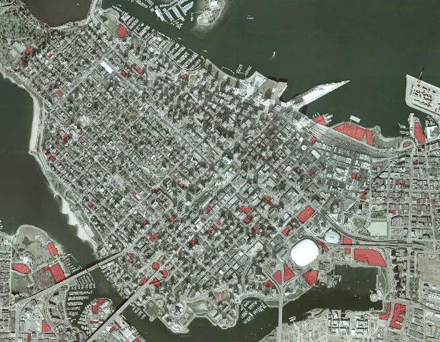
All the cities that have been added are here. I’m sure they’d welcome a contribution of Vancouver if someone wants to take the time.
UPDATE: Vancouver done!

UPDATE: Daniel Bowen – Average Australian – was inspired to do a map of the Hoddle Grid in Melbourne.
UPDATE: Frances Bula explores reduced parking demand in downtown Vancouver in this piece in The Globe and Mail.


Downtown Langley http://www.southfraser.net/2011/09/parking-parking-everywhere-in-city-of.html
I did this for the City I worked for once … it was pretty crazy what the results were. I think something like 50% of the land downtown was dedicate to surface parking …
Remember that surface parking is typically a placeholder for redevelopment of the parcel (one that generates prevenue at little capital cost). If you compare a Vancouver aerial from 1980 to one today, you’d see that many parking lots of the past have been built on – it just needs the right economic conditions. Older buildings are often torn down because of the lack of tenants willing to locate in them, the cost of renovating what will be torn down when redeveloped and the high cost of property taxes (higher than residential) for the “improved” lands.
More recently, we’ve seen community gardens as placeholders because they lower the property taxes even lower than a parking lot would do.
Spot on!
I think in Houston, if you compare that situation to 20 years ago you would probably find much the same appearance. In many cities this goes beyond simple placeholder status to that is really the permanent situation on the ground. It’s going to take more than simply waiting around for that to change.
Vancouver is already done: http://forum.skyscraperpage.com/showpost.php?p=5306008&postcount=78
These photos are a little unfair for comparison — the scales are all different (look at the size of a Houston block vs the others, esp Vancouver) plus the red-coloured shading is different in Toronto and Vancouver than in Houston and Portland. The spatial contrast is of course obvious, but should have been demonstrated through a more honest portrayal.
There are other unfair comparisons that unfairly portray Houston in unlfattering light. If you compare the Houston image to the google arial image, you will also see that many parks and other non-surface parking was shown in red making it appear that the City is more surface parking heavy than it actually is.
While Houston does indeed have what seems to be an excessive amount of surface parking, it should be noted that Houston has only had light rail for less than 10 years (and still has no commuter rail), which forced many to drive in to the CBD. As the light rail system is expanded and light rail becomes the transit norm fror many, there will likely be reduced demand for parking and the economics will dictate other higher and best uses for these lots.
Also worthy of note, much of the red is concentrated in the bottom part of the image, which is the east side of the CBD. The city is expanding in that direction with the construction of sports venues and other public spaces and much of the new high rise construction is moving that direction. Eventually, much of that surface parking will be developed.
Ben has a point, if you blew out Houston more you would find their rather enormous park/flood plain. Still, you’d see some pretty dramatic strip mall layouts too.
I’ve had a go at a map of Melbourne’s CBD (excluding car parks outside the central “Hoddle Grid”) http://www.danielbowen.com/2012/01/07/melb-cbd-surface-parking/
Interesting is, that there is still enough crazy people who are trying to drive downtown instead of leaving car in the suburbs and coming by public transport. Especially in Toronto, where following this article Guide to Parking in TO is 13 minutes. If you go downtown every week two times, you probably loose 26 minutes. This makes 1352 minutes a year (22,3 hrs). And I´m not talking about the emissions.
Your Portland map seems to include a lot of just vacant undeveloped land along the rail line in the bottom right corner that is not currently surface parking or even paved.
Looking closer, the Portland map also includes a lot of industrial land on the periphery that are not really downtown at all.
Ha! Sorry to post again, but I also noticed some parking structures are colored like they are surface parking. Who ever colored this map was only looking at the sattelite image, and not very closely.
OK, Robert. But if what you say were taken into account and the photos adjusted accordingly, would the right message still get across with as much strength as it does now?
The google map image for Toronto is outdated by a couple of years. I would say about 1/3 of those lots have a condo on them now, and the other 2/3 have condos/offices under construction or planning stage. The days of surface parking lots in downtown Toronto are over in about 5 years.