
Well, ‘downtown’ Abbotsford isn’t technically a strip mall – though there aren’t many vestiges of its historic roots as a stop along the Yale Road to the goldfields of 1858. Or its farming community past. Today, it’s main drag really is a drag:

A classic case of a community that grew up in the pre-motordom era giving itself over to auto dominance (thank you, long-serving mayor George Ferguson) and turning its core into one big strip mall. Now the fifth largest municipality in the province, with an airport that could one day be the second aeronautical anchor of the Lower Mainland, Abbotsford would inevitably be absorbed into vast undifferentiated regional sprawl if it wasn’t for the Agricultural Land Reserve.
Meanwhile, keep your eyes on 16th Avenue, which I’m pretty sure the highway planners are. Imagine an expressway connecting with the Trans-Canada Highway, past the Abbotsford airport, streaking in a straight line across the ALR to the new interchange they’re planning to build on Highway 99 at White Rock, and serving all the expanded streets to the international border crossings. Won’t that do wonders for the ‘compact metropolitan region.’

But I digress. Appparently they’ve decided they have quite enough asphalt in Abbotsford, and now they’d like a little more transit. In particular, a frequent transit corridor sort of in the shape of a horseshoe:

Director of Community Planning Carl Johannsen provides a precis of Abbotsford’s ‘Local Transit Enhancement’ concept –
… a long-term vision to develop a high-frequency transit backbone through the City’s urban area, approved-in-principle by Council in November of 2008. The idea of future rapid transit (i.e. BRT) along much of the horseshoe has been also confirmed by Minstry of Transportation and Infrastructure’s Strategic Review of Transit in the Fraser Valley.
We aim to build up transit frequencies along these corridors over time, and reorganize the rest of system to feed into these corridors. The City, with BC Transit and the District of Mission, will also be developing a long-term transit vision (Transit Future Plan) for the Abbotsford-Mission transit system over the next months.
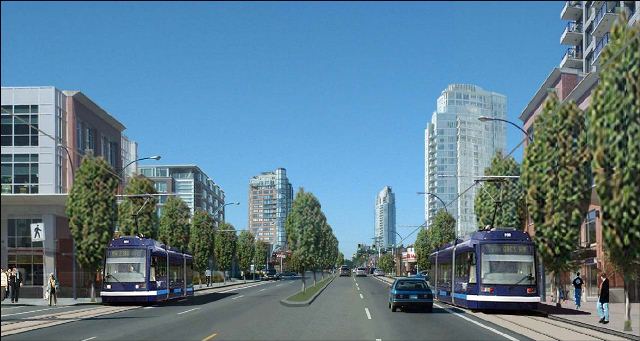
So in time, the grim gray corridor of South Fraser Way:

…might, from the same view at the top, look like this:


Never underestimate the attraction of Zero Avenue to highways planners for a second cross region freeway, which I have heard proposed as a good option since it avoids slicing right through the ALR. Not sure how the folks in Whatcom County or US Homeland Security would feel about that though – perhaps justification for a border wall as a sound attenuation barrier.
The strip mall is alive and well in Nanaimo. This is currently under construction in the heart of the downtown and has been enthusiastically promoted by the Planning Department.
http://nanaimocityhall.files.wordpress.com/2010/04/port-place-location-plan1.pdf
One despairs!
I love those before and after pics, and I like this animated gif that flicks between the two of them: http://i.picasion.com/pic39/49af270c4a0355585789741f33048219.gif
Google Maps Streetview is a good way to see alternative street designs I find. Here are a few pictures that show the different ways that road-owners (usually municipalities, I believe, using our money) can choose to design their asset for greatest social benefit. http://www.facebook.com/album.php?aid=53393&id=151076548254144